
This website uses cookies so that we can provide you with the best user experience possible. Cookie information is stored in your browser and performs functions such as recognising you when you return to our website and helping our team to understand which sections of the website you find most interesting and useful.

JD Project
JD Project
Overview
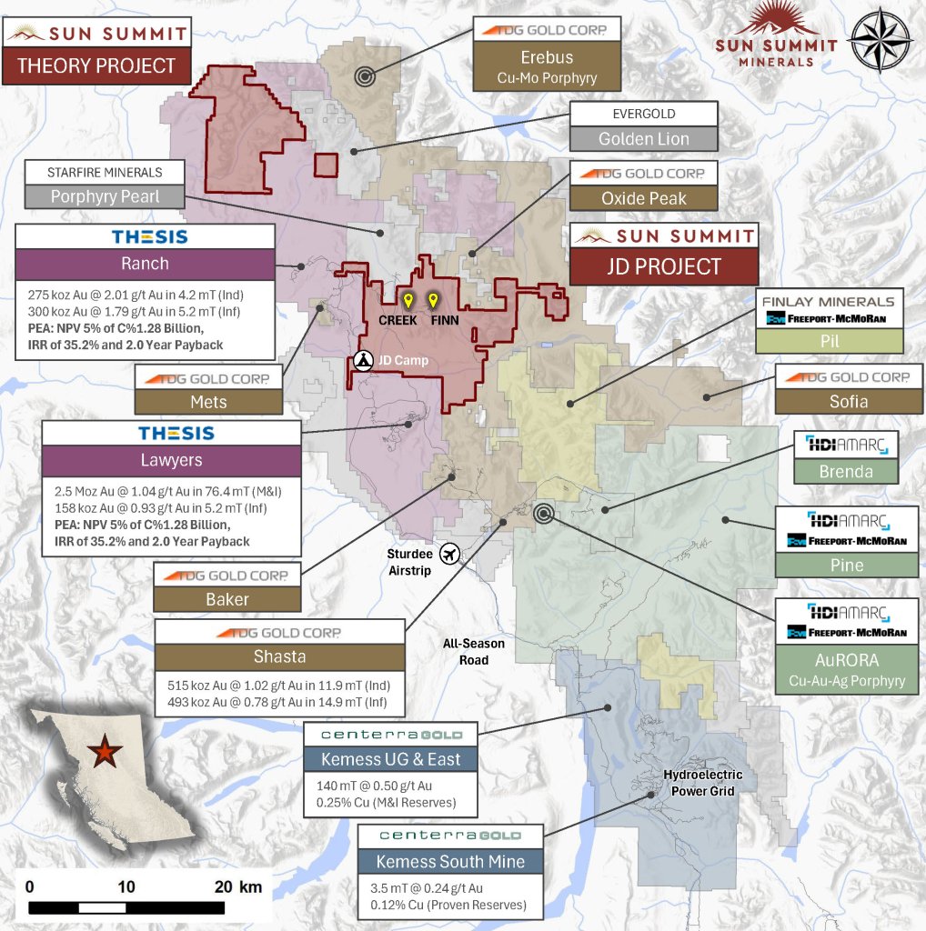
The JD Project is located in the Toodoggone mining district in north-central British Columbia, a highly prospective deposit-rich mineral trend with a rich exploration and mining history dating back to the gold rush of the 1930’s. The earliest history of mining in the Toodoggone district of B.C. began with placer mining in 1930 on McClair Creek and the Toodoggone River which today make up part of the larger JD Property. The project covers an area of over 15,000 hectares and is in close proximity to active exploration and development projects, such as Thesis Gold’s Lawyers and Ranch projects, TDG Gold’s Baker-Shasta projects, Amarc Resource’s AuRORA project, Centerra’s Gold’s Kemess East and Underground projects, as well as the past-producing Kemess South open pit copper-gold mine which operated from 1998 to 2013.
The project is 450 kilometres northwest of the city of Prince George, and 25 kilometres north of the Sturdee airstrip. It is proximal to existing infrastructure in place to support the past-producing Kemess South mine, including roads, the Kemess airstrip and a 230kv hydroelectric power line that connects to the BC Hydro grid at Kennedy substation near the Town of Mackenzie.
The JD Project is in a favourable geological environment characterized by both high-grade epithermal gold and silver mineralization, as well as porphyry-related copper and gold mineralization. Some historical exploration, including drilling, geochemistry and geophysics, has been carried out on the property, however the project area is largely underexplored.
Location & Infrastructure
- ~15,000 ha in BC’s Toodoggone district
- 450 km NW of Prince George
- 25 km north of Sturdee airstrip
- Access by air (Sturdee/Kemess airstrips) or road (460 km from Mackenzie)
- All-weather gravel road to JD Camp on the Toodoggone River
- Near infrastructure from the past-producing Kemess South Mine, including 230 kV hydro line that connects the mine to the BC Hydro Kennedy Sub-station near Mackenzie
- Surrounded by active projects:
- Thesis Gold – Lawyers, Ranch
- TDG Gold – Baker-Shasta
- Amarc/Freeport – JOY, Brenda
- Centerra Gold – Kemess East & Kemess North Underground
Geology & Mineralization
The Toodoggone district hosts a significant number of shallow, high- and low-sulfidation epithermal-type mineral deposits and occurrences (e.g., JD, Lawyers, Shasta, Baker) as well as porphyry-related mineralization (e.g. Kemess, Brenda, Pine) that may be contemporaneous and potentially cogenetic. These deposits are hosted by a thick (>2 km) succession of well-preserved, Early Jurassic sub-aerial andesitic and dacitic volcanic rocks of the Toodoggone Formation (Hazelton Group).
The JD Project is characterized by both high-grade epithermal gold and silver mineralization, as well as porphyry-related copper and gold mineralization. The epithermal-related systems, locally dispersed over a ~5 km east-west trend, are poorly explored and represent high-grade gold and silver mineralization potential.

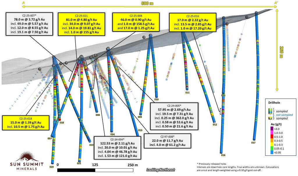
Creek to Finn Corridor
The Creek to Finn Corridor is a 4.5-kilometre mineralized trend linking the JD Project’s Creek and Finn Zones, where drilling has returned high-grade gold & silver results. Multiple undrilled geophysical and geochemical anomalies remain open along the corridor, representing additional discovery potential as the JD Project advances toward an inaugural mineral resource estimate.
Creek Zone
- High-grade, vein-hosted gold + base metal mineralization within broad zones of bulk-tonnage style gold mineralization
- 2025 program confirmed strong high-grade gold potential:
- 2024 program confirmed presence of continuous disseminated mineralization from surface
- Anomalous surface geochemistry proves near-surface potential
- IP geophysics confirmed chargeability and resistivity highs that require further testing
- Limited drilling (PDF), mineralization open in most directions
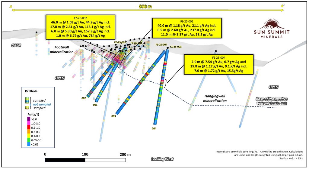
Finn Zone
- Broad zone of near-surface, epithermal-related gold-silver mineralization
- Structurally controlled mineralization
- Prior drilling in high grade core; subsequent drilling confirmed continuity of mineralization
- ~270 historical drillholes (PDF)
- 35.7 m @ 7.3 g/t Au incl. 1.0 m @ 215.4 g/t Au (JD95 -0472)
- 22 m @ 12.5 g/t Au incl. 0.8 m of 171.5 g/t Au (JD95 -0642)
- 27.8 m @ 6.6 g/t Au incl. 11.0 m @ 15.1 g/t Au (JD95 -0972)
- 77 m @ 2.4 g/t Au incl. 12.6 m @ 10.8 g/t Au (JD12 -0035)
- 45 m @ 3.0 g/t Au, 143 g/t Ag (JD95 -0762)
- Open along strike and down dip
- Extensive mineralized footprint open at depth

2025 Exploration Program
- 6,864 metres diamond drilling (21 holes)
- Soil geochemistry (1,500 soil samples)
- Prospecting & Geological Mapping (120 rock samples)
- 58-line km of IP Geophysics
- 35 km JD Porphyry Trend
- 23 km Finn–Creek corridor
- Camp upgrades and road design engineering
JD Maps & Figures


JD Photo Gallery


References
- Krause, R.G. (1995), 1994 Geological and Geochemical Report on the JD Gold Silver Property, Toodoggone River Area, Omineca Mining Division, British Columbia, Assessment Report Indexing System, Report 23663, https://apps.nrs.gov.bc.ca/pub/aris. JD94-01 to 32
- Krause, R.G. (1996), 1995 Geological Report on the JD Gold Silver Property, Toodoggone River Area, Omineca Mining Division, British Columbia, Assessment Report Indexing System, Report 24284, https://apps.nrs.gov.bc.ca/pub/aris. JD95-33 to 132
- Hawkins, P.A. (1998), 1997 Exploration Report on the Creek Zone for Antares Mining and Exploration Corporation and AGC Americas Gold Corporation, JD Property, Toodoggone River Area, Omineca Mining Division, Internal Report #98-065-1. CZ97-01 to CZ97-08
- Davis, J.W., and Jamieson, M.D. (1998), Drilling and Geophysical Report on the M.H. Mineral Clain Group, Toodoggone District, Assessment Report Indexing System, Report 25757, https://apps.nrs.gov.bc.ca/pub/aris. CZ98-09 to CZ98-15
- McBride, S. (2013), 2012 Geological, geochemical and diamond drilling report on the JD Property, Assessment Report Indexing System, Report 33556, https://apps.nrs.gov.bc.ca/pub/aris. JD12-01 to 18, rock and soil samples 1710212 to 1716000
- McBride, S. and Leslie, C. (2014), 2013 Geological, geophysical and diamond drilling report on the JD Property, Assessment Report Indexing System, Report 34762, https://apps.nrs.gov.bc.ca/pub/aris. JD13-19 to 28, rock samples 1709401 to 1709477
- Ranch and Lawyers: Thesis Gold Inc. (https://thesisgold.com) and NI 43-101
- Shasta and Baker: TDG Gold Corp. (https://tdggold.com) and NI 43-101
- Kemess North UG: Centerra Gold 2022 Year-End Mineral R&R Summary (https://www.centerragold.com)
Disclaimer
This information has been reviewed and approved by Sun Summit’s Vice President Exploration, Ken MacDonald, P. Geo., a “Qualified Person” as defined in National Instrument 43-101 Standards of Disclosure for Mineral Projects of the Canadian Securities Administrators. He has not been able to verify the historical exploration data disclosed, including sampling, analytical and test data, underlying the technical information in this news release since such data is historical and the original drill core is not readily available. Technical information contained in this release is historical in nature and has been compiled from public sources believed to be accurate. The technical information has not been verified by Sun Summit and may in some instances be unverifiable dependent on the existence of historical drill core and grab samples.